GENERAL INTRODUCTION & SUMMARY |
This web site is written as a record and personal tribute to the work of my many colleagues in the SEE IT team over the two years, March 1985 to March 1987. The text is based on my own "Final Report" to the Derbyshire County Council but has linked pages to examples of the many "products" of a very productive two years. The inspiration for the project came from Ron Marquand of the County Planning office and we owed much to his support and guidance.
 The
Scheme commenced in March 1985 and entered its second year in March 1986.
As is characteristic for Community Programme schemes, only a small core of
full-time staff continued on from the first year. The personnel complement
in Year 1 was two full-time management staff, two full-time and twenty-six
part-time employees. Year 2 had a maximum complement of two full-time
management staff, four full-time and twenty-nine part-time employees.
Although the emphasis was on integrated teamwork, with very few tasks being undertaken in isolation, for managerial convenience, there were five working teams. These were; Environmental Interpretation; Historical Interpretation; Route Planning and Activities; Presentation; and Administration. The first two teams contained researchers and interpreters (although the distinction was somewhat blurred); the third had planners; the fourth had graphic artists and photographers; and the fifth, led by the scheme's administrative officer, had the scheme's typists and maintenance staff.
Close collaboration took place with the Country Park staff and other Planning Department staff. Working links were established with other interested parties, such as education staff (schools, colleges and Departmental), social services staff and local history societies.
Many members of the public contributed archival and other material and they were very welcome visitors to "The Gardens".
During its two years of
existence, the Shipley Environmental Education and Interpretation Team (SEE
IT) produced an extremely wide range of printed interpretative
publications. These encompassed a Shipley Country Park Map; six
booklets (two Nature Trails, two versions of a Tree Trail,
Coarse Fishing, the history of The Gardens of Shipley Hall);
twelve leaflets (six historical, four on natural history, two Discovery
Trails); a Wayfaring Course map; a Colouring Book; five
card cut-out model sets (Shipley Hall, The Stable Yard,
Shipley Hall 3D, Military Men), and, Costumes; and a Bat study
pack with a card cut-out mobile.
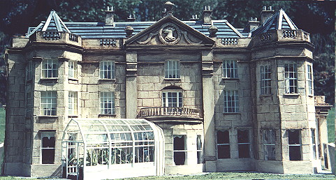
Display Panels (of the Park Map and for the Mapperley Reservoir), together with six multi-panel exhibition displays (Shipley Hall & Gardens, The Nutbrook Canal, Hosiery & Lace, Coal Mining, Architecture of the Shipley Estate, Leaves and Grasses, SEE IT scheme), a scale model of Shipley Hall and a relief map of the Country Park were completed.
Audio-visual video films were made on the Natural History of the Country Park, the Nutbrook Canal, a General View of the Park and the History of the Park.
Detailed environmental surveys and studies were made of all the major areas of the Country Park. From these, a number of specialist reports, habitat appraisals, management plans and schools activity materials were completed. Together, these formed a major resource of study materials.
A unique and very extensive collection of historical documents and maps was assembled, catalogued and, partially, summarised in research papers. Educational study materials have been prepared for, and utilised by, school teachers. A BBC Computer database of genealogical information was developed.
Many photographic slides and prints, both contemporary and historical were assembled. In addition to those used in the publications and exhibitions, some were used for a publicity poster for the Country Park or for a set of Postcards.
Last but not least, two major reports were produced on facilities in the Country Park for disabled persons and for cyclists. The latter, which would provide extremely useful information for the proposed cycle hire facility, also outlined a number of access routes and touring routes relative to the park.
The scheme provided employment for a total of 66 people, some 44 of whom hold degrees or equivalent qualifications. It served particularly well in providing the first professional employment for many young graduates, who learnt much on how to plan and carry out work programmes.
Many illustrations are used.
Notes on this web site, etc.
For convenience of the reader, a number of the illustrations are edited versions of the originals, for instance, labels or label panels have been added to images of individual panels from the leaflets.
The format of the SEE IT leaflets was decided early on as being a folded dimension equal to one-thirds A4. Individual leafets would have 8 or 10 panels but essentially no more to keep the quantity of information compact. For booklets we adopted an A5 format. To minimize printing costs a combination of black plus one other colour of ink and a coloured paper was used for all publications.
The many leaflets and booklets were put on sale at the Park Visitor Centre with copies being deposited with local libraries.
| Comments to dr.brian.taylor@ntlworld.com | href="/shipley/general.htm" |