 The History of the Parish Church of
St. Mary the Virgin, Nottingham - In
the Beginning
The History of the Parish Church of
St. Mary the Virgin, Nottingham - In
the Beginning
The History of the Parish Church of
St. Mary the Virgin, Nottingham - In
the Beginning
This is not a history of Nottingham but because the great church of St. Mary The Virgin is so inextricably linked with the town from its earliest recorded days that we have to start with a little on the town and its geography.
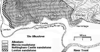
The modern city is centred on four sandstone bluffs bounded by cliffs; the stone being known as the "Nottingham Castle Sandstone" and too soft for use in construction. From east to west the bluffs are Sneinton Hermitage, the Lace Market, Castle Rock and the western area of the Park. Between each bluff there is an incised southward directed valley, cut by a tributary of the Trent. Only one bluff, that now called the Lace Market but perhaps better named as St. Mary's Hill, where there is a 500 metre length of cliff capped by a flat area, was sufficiently large for a defensible town to be built. The map shows something of the underlying geology and the contours of the four hills which form good defensive peninsulars overlooking the flood plain of the great river Trent. Not only are they easy to defend but the middle hill lay on the line of the road running from the lowest crossing of the river.
The earliest settlement, St. Mary's Hill, was where Snot
had his Ham (hamlet, or
village, often one without a church) - Snotingeham.
Snot also gave his name to the neighbouring Snot's Ton (or hill) - Snenton
(the Sneinton of today). After the Norman Conquest, of which more later,
the Ham formed the old "English" Borough.
The meadows below, with the lesser River Leen running below the cliffs, would have given good summer grazing and land for growing fodder. Additionally, the soft Nottingham Castle sandstone was easily excavated to make cave dwellings, both cool in summer and warm in winter, and dry. Indeed, the abundance of cave dwellings led to another early Anglo-Saxon name "Tigguo-Cobauc" - habitation of caves. To this small but strategically important town perhaps came one of the early Christian evangelists, St. Paulinus, in around 664 AD, and St. Wilfrid, baptizing converts in one of the rivers and encouraging them to build a church on the highest point, visible for miles around as witness to the new Christianity. This point, which might previously have been a place of pagan worship, as it proved a good tactic to absorb earlier sacred sites, is where St. Mary's is to be found.
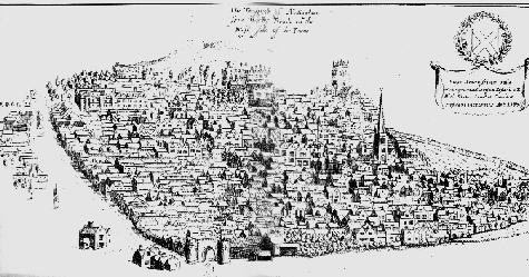
A view (right) from the summit of the approach from Derby, although much later in time, shows how prominent the new church would have been.
Some time before 868 AD, the Danes had occupied and fortified the town, probably because of its defensive significance. In 868, "Burhed, King of Mercia, with Aethelred, King of Wessex, and his brother Alfred....". travelled with the West Saxon army into Mercia as far as Nottingham, and met the raiding-army there in the fortification. The old Great North Road, known as Stane Street, the original spelling of the existing Stoney Street alongside the east of St. Mary's, ran through the town. The lowest safe ford on the River Trent was at what is now known as West Bridgford. In 919-20 AD, King Edward (I) recaptured the town from the Danes and ordered it to be repaired, or improved and occupied, both with Englishmen and with Danish.. Around that time the county was added to the Diocese of York and became a key centre of royal administration with a regional role throughout the Midlands. King Edward returned and ordered a stronghold to be made opposite the other on the south side of the river, and the bridge, the Hethbethebrigg was built on the Trent between the two strongholds. For some 150 years it remained the lowest bridged crossing on the river.
With the improvement of the town and its inclusion in the Diocese of York, in 930 AD, a Witangemot, or high level church meeting, attended by the Archbishop and 16 Bishops was held in Nottingham. One has to assume this would have required there to be a significant church available for their worship, if not the meeting itself. Blackner cited "William of Malmsbury" as writing "about the year 974, King Edgar issued large sums from his treasury (probably at the instigation of Dunstan, Archbishop of Canterbury, under whose influence the king was guided) for repairing places of public worship, which were then built of wood, and covered with shingles, and were so rotten as not to admit of public worship being performed in them". Whether or not the church in Nottingham was in a poor state, at least this tells us of the probable nature of the building.
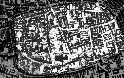
Apart from the earliest church, probably on the present site, it seems that large timber halls stood immediately to the west of St. Mary's Gate on what now is Halifax Place, possibly forming the palace of a local ruler and dating from the eighth century. The cliffs may not have been so precipitous and (my guess) may have resembled the wooded slopes still in existence to the east of Sneinton. Stone halls were found from the eleventh to twelfth centuries, fronting on to High Pavement, which was the principal street in this earliest period. Major fortifications, by means of timber rampart and a ditch on the northern (the only easily passable area) boundary are likely to have been constructed in the era of Edward the Elder (around 918-920). The streets, or Gates to use the Danish word, have remained almost unchanged and, thus, the layout of the town can be seen as the highlighted area of the map dating from 1831. Even today the only significant changes are on the eastern edge, with the road changes around the new National Ice Centre, actually built on what is shown on this map as "St. Mary's Burial Ground".
This earliest era closes with the reign of Edward the Confessor, as after his death, in 1066, Harold took over the throne, which had been promised to William, Duke of Normandy. This was the trigger for the Norman Conquest.
![]() 1066 and all that
1066 and all that ![]() Return to History - Introduction
Return to History - Introduction ![]() Main Home Page
Main Home Page
St. Mary's, Nottingham, History - In the Beginning. Compiled by Brian Taylor, published September 2000
stmarys/history1.htm