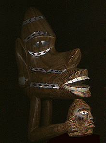
The "Nusu Nusu" traditional canoe prow, ever-watchful for
enemies (local modern miniature carving) |
The Solomon Islands - A Visual Geography
from West to East Images taken by
Brian Taylor The Solomon Islands, apart from a few
tourist areas, remain well off the track of the more usual world
traveller and so these images are presented here as a fond personal
memoir and to bring the very beautiful islands into view. The collection
was taken while I was Government Entomologist with the national Malaria
Eradication Programme from October 1969 to July 1973, and are assembled
the in a roughly west to east order. Most of the geographical summaries
are taken from my own writings, notably the
Review of the Mosquito Fauna of the Solomon Islands. The various
maps are derived from a number of sources - most of the line maps are
those I used for the mosquito papers see
this link, and the others I have prepared by extracting from and
adding to the Directorate of Overseas Surveys maps of 1969. None should
be taken as providing definitive information on modern boundaries.
Some of the earlier photographs have suffered from being taken with
unstable film. I have tried to restore something of the colour and to
clean up other defects. Although not 100% successful, I have used the
photos as they make the record much more complete, please accept them
as they are.
The various images of carvings and ornaments are from among our
personal collection of modern artefacts.
|
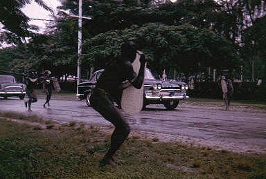
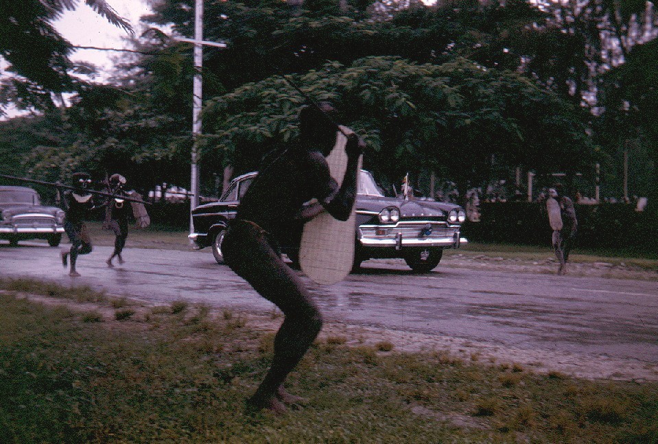
Title: The Warrior's Challenge
Royal Visit, 1971

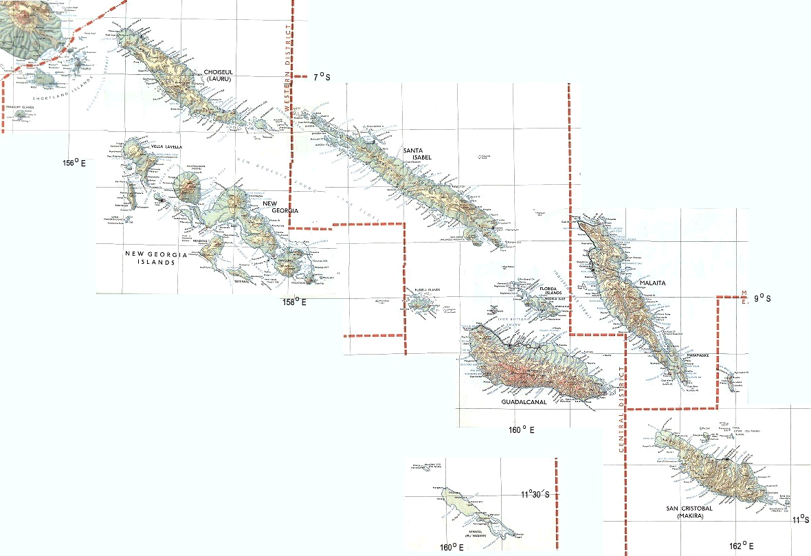
Title: The Solomon Islands |

Title: The Solomon Islands - outline map |
|

Title: The Eastern Outer Islands |
| Key to maps |

Location of photos from on-board ship |

Location of aerial photos |

Location of photos from on land |
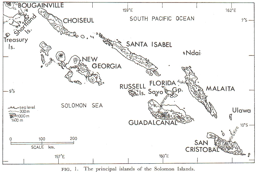
General Geography
(compiled by me in 1975)
The Solomon Islands comprise a scattered archipelago of mountainous
islands of continental character formed by tectonic folding, and with
numerous extinct and dormant volcanic cones and low-lying coral atolls.
The major islands form a double chain stretching southeasterly for 850 km
from the Shortland Islands to Ulawa and Santa Ana, lying between 5°S
to 11°55'S and 155°30'E to 162°55'E. The major islands are,
to the north, Choiseul, Santa Isabel and Malaita and, to the south, New
Georgia, Guadalcanal and San Cristobal. Numerous smaller islands and
groups of islands are interspersed in the double chain while to the north
and east lie the coral atolls of Ontong Java and Sikaiana, and to the
south lie the raised coral islands of Rennell and Bellona. The isolated
Eastern Outer Islands are described separately below.
The major islands are characterized by precipitous, thickly forested,
mountain ranges intersected by deep narrow valleys. The coasts are
frequently surrounded by extensive coral reefs and lagoons and there arc
widespread mangrove swamps in many areas. Guadalcanal is unique in having
a large expanse of flat grassy plain on the north-central side of the
island.
The climate is equatorial but is modified by the surrounding ocean. The
annual mean temperature is around 27°C at Honiara, the capital on
Guadalcanal, and at Kira Kira, on San Cristobal, the temperatures between
1965 and 1970 ranged between an average maximum of 29.6°C and an
average minimum of 22.2°C. The annual rainfall for the Solomon
Islands as a whole averages 3000 to 3600 mm. However the outer coasts of
the island chain are considerably wetter than the inner coasts. This is
well illustrated by data from Malaita where the average annual rainfall
recorded at stations on the west (inner) coast is 3182 mm at Auki (based
on figures for 1926-50 and 1954-64), 3608 mm at Dala (1962-65 and
1968-69), 3571 mm at Malu'u (1962-65) and 3335 mm at Hauhui (1963 and
1967-69), but on the east (outer) coast the averages are 4838 mm at
Nafinua (1961-65) and 4835 mm at Kwai (1962-66 and 1969). In some areas
the annual rainfall can be as much as 7600 mm. In recent years cyclones
have apparently become more frequent and these can bring enormous
downpours: in April 1970 at Auki, where the average April rainfall is 274
mm, the month's rainfall totalled 917 mm of which 386 mm fell in one day.
There are rarely long periods without rain and this, in combination with
the relatively high temperature and humidity, gives conditions which are
usually very favorable for the development and longevity of mosquitoes.
Consequently, the mosquito-borne diseases malaria and filariasis are
extremely prevalent.
The total population of the Solomons in February 1970 was over 139,500
with an overall density of 5.8 persons per km², varying on the large
islands from 11.8 per km² on Malaita to 2.16 per km² on Santa
Isabel. The overall population growth between February 1970 and July 1973
was estimated as being over 11%. With the exception of the inland
populations on Guadalcanal, Malaita and, to a lesser extent, San
Cristobal, and a few inland villages on Choiseul and Santa Isabel, the
people all live in close proximity to the sea on the typically narrow
coastal strips of flat land or on lagoon islands.
Honiara is the only large town with over 17,000 inhabitants, although
there are small townships at Auki, the Malaita District headquarters,
Gizo, the Western District headquarters, and Yandina, Russell Islands.
Ports of entry for overseas shipping are Honiara, Gizo, Yandina and Ringgi
Cove, Kolombangara. International airports are at Henderson Field, near
Honiara, and at Munda, New Georgia.
The majority of the people are engaged in subsistence farming and
fishing. Their only important cash crop is the coconut palm. Copra, the
dried flesh of the coconut fruit, is one of the main exports and large
commercial plantations are found on northern Guadalcanal, tlie Russell
Islands and elsewhere. Other agricultural projects on a commercial scale
are rice, oil palm and cattle production, all on northern Guadalcanal,
although there are considerable numbers of cattle in the Russell Islands,
where they are used to keep the undergrowth short in the coconut
plantations. Timber is a major export with large forestry operations on
Kolombangara at Ringgi Cove, on New Georgia at Viru Harbour and on Santa
Isabel at Allardyce Harbour, although the last was severely disrupted by a
cyclone in 1972. Fishing on a commercial scale based at Tulagi was started
in the early 1970's. Potential mining operations for bauxite, on Rennell
and Waghena, and for nickel ore, on San Jorge, are still being evaluated.
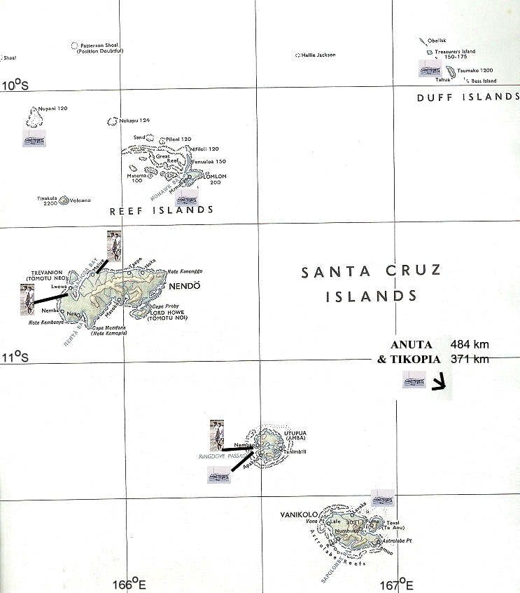
Eastern Outer Islands
The islands of the Santa Cruz Group are perhaps the most isolated and
least visited in the Southwest Pacific. Politically and administratively
known as the Eastern Outer Islands, the islands lie at the extreme eastern
end of the 1600 km long Solomon Archipelago. The islands, which have a
total land surface of only 836 km², are scattered over a wide area of
the Coral Sea (9°30' to 12°30'S and 165°30' to 170°30'E).
The nearest lands are to the south, the Torres Group of islands at the
northern tip of the New Hebrides, over 150 km away; 400 km to the west is
San Cristobal in the main Solomons. However, the Santa Cruz group is
separated from the main Solomons by the Torres trench, over 6000 m deep.
Apart from the isolated islands of Tikopia, Anuta and Fataka, the group
lies on the same submarine ridge as Vanuatu (New Hebrides).
Their climate has the seasonal characteristics typical of tropical
islands lying in the zones of the tradewinds. Rainfall can be
considerable, particularly when mountains are present as on Vanikoro. The
population is approximately 9000 (1970 Census) with a predominance of
Melanesians on the larger islands and Polynesians on the others. The
average density is 10.8 persons per km² with variations from 1.1 on
Vanikoro to 201 on Tikopia. Though recent evidence suggests that the
movements of populations in the subarea have been quite extensive in the
remote past, Tikopia and Anuta have remained relatively isolated, whereas
cultural and commercial interchanges seem to have been continuous and
active between the Santa Cruz Group, the Reef Islands and the Duff
Islands.
Northern outliers
Ndai - A small, 6 km long, isolated island, north of Malaita at
7°55'S and 160°E, with a single village of about 80 people (in
1970).
Ontong Java - The second largest coral atoll in the Pacific, 75
km long and up to 25 km wide, lying between 5°-5°32'S and 159°15'-159°40'E,
at the northern limits of the Solomons. In 1970 the about 900 Polynesian
inhabitants lived on two of the small islands (Pelau and Liuaniua,
combined land area 7.8 km²).
Sikaiana - An isolated coral atoll, lying about 8°27'S and
162°50'E. with a maximum width of 20 km. The about 200 (in 1970)
Polynesian inhabitants lived on Sikaiana (Taini) Island with an area of
2.6 km². A man from Sikaiana is in one of my photographs taken in the
Reef Islands.
Ulawa - A relatively small narrow island, lying about 9°45'S
and 161°55'E, some 20 km long and up to 5 km wide. In 1970 the about
1500 inhabitants lived in coastal villages. I visited there briefly but
took no photographs.
Current situation - In 1970 the total population of the islands
was around 186,000, now it is in excess of 430,000. The single large town
and capital, Honiara, then with around 17,000 inhabitants, now is home to
over 40,000 people. Most of these are from outside of Guadalcanal, which
has led to increasing unrest, coupled with the large numbers of
non-Guadalcanalese working for the major agricultural enterprises of the
oil palm and rice enterprises, and latterly, the Gold Ridge Mine.
 2. Choiseul
 |
3. Shortlands Group |
4. New Georgia Group |
5. Central Solomons |
|
6. Savo & Guadalcanal |
7. Honiara |
8. Florida Group |
9. Rennell & Bellona |
|
10. Malaita |
11. San Cristobal (Makira) |
 12. End - Eastern Outer Islands
 |
|
©2000 - Brian
Taylor CBiol FIBiol FRES
11, Grazingfield, Wilford, Nottingham, NG11 7FN, U.K.
Visiting Academic in the Department of Life Science, University of
Nottingham
|
This page was created with ArcSoft Media
Browser 2000.
Page 1 of 12